Saint Pierre and Miquelon
North Atlantic overseas collectivity of the French Republic / From Wikipedia, the free encyclopedia
Dear Wikiwand AI, let's keep it short by simply answering these key questions:
Can you list the top facts and stats about Saint Pierre and Miquelon?
Summarize this article for a 10 years old
Saint Pierre and Miquelon (/ˈmɪkəlɒn/),[3] officially the Territorial Collectivity of Saint-Pierre and Miquelon (French: Collectivité territoriale de Saint-Pierre et Miquelon [sɛ̃ pjɛʁ e miklɔ̃]), is a self-governing territorial overseas collectivity of France in the northwestern Atlantic Ocean near the Canadian province of Newfoundland and Labrador.[4][5] An archipelago of eight islands, Saint Pierre and Miquelon is a vestige of the once-vast territory of New France.[4] Its residents are French citizens; the collectivity elects its own deputy to the National Assembly and participates in senatorial and presidential elections. It covers 242 km2 (93 sq mi) of land and had a population of 6,008 as of the March 2016 census[update].[1]
Saint Pierre and Miquelon | |
|---|---|
Overseas collectivity of France | |
| Territorial Collectivity of Saint-Pierre and Miquelon Collectivité d'outre-mer de Saint-Pierre-et-Miquelon | |
| Motto: | |
| Anthem: La Marseillaise ("The Marseillaise") | |
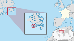
 Location of Saint Pierre and Miquelon in North America. | |
| Country | |
| Cession from the United Kingdom | 30 May 1814 |
| Current status | 28 March 2003 |
| Capital and largest city | Saint-Pierre 46.7778°N 56.1778°W / 46.7778; -56.1778 |
| Official languages | French |
| Demonym(s) |
|
| Government | Devolved parliamentary local authority within French Republic |
| Emmanuel Macron | |
• Prefect | Christian Pouget |
| Bernard Briand | |
| Legislature | Territorial Council |
| French Parliament | |
• Senate | 1 senator (of 377) |
| 1 seat (of 577) | |
| Area | |
• Total | 242 km2 (93 sq mi) |
• Water (%) | negligible |
| Highest elevation | 240 m (790 ft) |
| Population | |
• March 2016 census | 6,008[1] |
• Density | 25/km2 (64.7/sq mi) (not ranked) |
| GDP (PPP) | 2004 estimate |
• Total | €161.1 million[2] |
• Per capita | €26,073[2] |
| Currency |
|
| Time zone | UTC−03:00 |
| UTC−02:00 | |
| Date format | dd/mm/yyyy (AD) |
| Driving side | right |
| Calling code | +508 |
| ISO 3166 code | |
| Internet TLD | .pm |

The islands are in the Gulf of St. Lawrence near the entrance of Fortune Bay, which extends into the southwestern coast of Newfoundland, near the Grand Banks of Newfoundland.[6] St. Pierre is 19 km (12 mi) from Point May on the Burin Peninsula of Newfoundland and 3,819 km (2,373 mi) from Brest, the nearest city in Metropolitan France.[7] The tiny Canadian Green Island lies 10 km (6 mi) east of St. Pierre, roughly halfway to Point May.
