Northeast megalopolis
Megaregion of the U.S. / From Wikipedia, the free encyclopedia
Dear Wikiwand AI, let's keep it short by simply answering these key questions:
Can you list the top facts and stats about Northeast megalopolis?
Summarize this article for a 10 years old
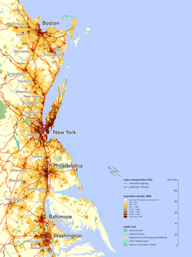
The Northeast megalopolis, also known as the Northeast Corridor, Acela Corridor,[3] Boston–Washington corridor, BosWash, or BosNYWash,[4] is the world's largest megalopolis by economic output[5] and the second-most populous megalopolis in the United States with about 50 million residents as of 2020.
Northeast megalopolis | |
|---|---|
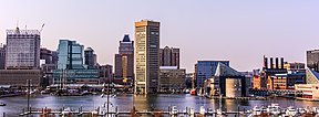
Major cities of the Northeast megalopolis (from top to bottom): Boston, New York City, Philadelphia, Baltimore, and Washington, D.C. | |
| Nickname(s): Northeast corridor, BosWash, Boston–Washington corridor, Eastern Seaboard,[1] Atlantic Seaboard | |
 Population density in the Northeast megalopolis along the Atlantic Seaboard | |
| Federal districts | |
| Largest city | |
| Area | |
| • Total | 56,200 sq mi (146,000 km2) |
| Population (2020[2]) | 49,401,918 |
| • Density | 879/sq mi (339/km2) |
Located primarily on the Atlantic Coast in the Northeastern United States , the Northeast megalopolis runs primarily northeast to southwest from the northern suburbs of Boston to Washington, D.C.[6] It includes many of the nation's most populated cities, including New York City, Philadelphia, Baltimore,[7] along with their metropolitan areas and suburbs. It is sometimes defined more broadly to include urban regions beyond these, including Richmond and Hampton Roads regions to the south; Portland, Maine and Manchester, New Hampshire to the north; and Harrisburg, Pennsylvania, to the west.[8]
The Northeast megalopolis extends in a roughly straight line along a section of U.S. Route 1 and Interstate 95. As of 2010, the region contained over 50 million people, about 17% of the U.S. population on less than 2% of the nation's land area, with a population density of approximately 1,000 people per square mile (390 people/km2), compared to the U.S. average of 80.5 per square mile[9] (31 people/km2). America 2050 projections estimate the area will grow to 58.1 million people by 2025.[10]
French geographer Jean Gottmann popularized the term megalopolis in his 1961 study of the region, Megalopolis: The Urbanized Northeastern Seaboard of the United States. Gottmann concluded that the region's cities, while discrete and independent, are uniquely tied to each other through the intermeshing of their suburban zones, taking on some characteristics of a single, massive city: a megalopolis, a term he co-opted from an ancient Greek town of the same name that named itself out of aspirations to become the largest Greek city.
The Northeast megalopolis is home to hundreds of colleges and universities, including some of the world's most elite universities, such as Harvard and MIT, both in Cambridge, Massachusetts; Yale in New Haven, Connecticut; Columbia in New York City; Princeton in Princeton, New Jersey; Penn in Philadelphia; Johns Hopkins in Baltimore; and Georgetown in Washington, D.C., all of which rank among the top in the nation in the 2022-23 U.S. News & World Report Best Colleges Ranking.[11]
.jpg/288px-Boston_-_panoramio_(23).jpg)


.jpg/288px-2018.06.07_Capital_Pride_Heroes_Gala%2C_Washington%2C_DC_USA_02939_(41773681885).jpg)