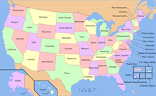
Geography of the United States
From Wikipedia, the free encyclopedia
The term "United States," when used in the geographical sense, refers to the contiguous United States (sometimes referred to as the Lower 48), the state of Alaska, the island state of Hawaii, the five insular territories of Puerto Rico, Northern Mariana Islands, U.S. Virgin Islands, Guam, and American Samoa, and minor outlying possessions.[1] The United States shares land borders with Canada and Mexico and maritime borders with Russia, Cuba, The Bahamas, and many other countries, mainly in the Caribbean[note 2]in addition to Canada and Mexico. The northern border of the United States with Canada is the world's longest bi-national land border.

 | |
| Continent | North America |
|---|---|
| Coordinates | 38.000°N 97.000°W / 38.000; -97.000 |
| Area | Ranked 3rd/4th |
| • Total | 9,826,675 km2 (3,794,100 sq mi) |
| • Land | 93.24% |
| • Water | 6.76% |
| Coastline | 19,920 km (12,380 mi) |
| Borders | Canada: 8,864 km (5,508 mi) Mexico: 3,327 km (2,067 mi) |
| Highest point | Denali 6,190.5 m (20,310 ft) |
| Lowest point | Badwater Basin, −85 m (−279 ft) |
| Longest river | Missouri River, 3,767 km (2,341 mi) |
| Largest lake | Lake Superior 58,000 km2 (22,394 sq mi) |
| Climate | Diverse: Ranges from warm-summer continental in the far north to tropical in the far south. West: mostly semi-arid to desert, Mountains: alpine, Northeast: humid continental, Southeast: humid subtropical, Coast of California: Mediterranean, Pacific Northwest: cool temperate oceanic, Alaska: mostly subarctic, Hawaii, South Florida, and the territories: tropical |
| Terrain | Vast central plain, Interior Highlands and low mountains in Midwest, mountains and valleys in the mid-south, coastal flatland near the Gulf and Atlantic coasts, complete with mangrove forests and temperate, subtropical, and tropical laurel forest and jungle, canyons, basins, plateaus, and mountains in west, hills and low mountains in east; intermittent hilly and mountainous regions in Great Plains, with occasional badland topography; rugged mountains and broad river valleys in Alaska; rugged, volcanic topography in Hawaii and the territories |
| Natural resources | Coal, copper, lead, molybdenum, phosphates, rare earth elements, uranium, bauxite, gold, iron, mercury, nickel, potash, silver, tungsten, zinc, petroleum, natural gas, timber, arable land |
| Natural hazards | Tsunamis; volcanoes; earthquake activity around Pacific Basin; hurricanes along the Atlantic and Gulf of Mexico coasts; tornadoes in the Midwest and Southeast; mud slides in California; forest fires in the west; flooding; permafrost in northern Alaska |
| Environmental issues | Severe water shortages, air pollution resulting in acid rain in both the US and Canada |
| Exclusive economic zone | 11,351,000 km2 (4,383,000 sq mi) |