Geography of France
Overview of the geography of France / From Wikipedia, the free encyclopedia
Dear Wikiwand AI, let's keep it short by simply answering these key questions:
Can you list the top facts and stats about Geography of France?
Summarize this article for a 10 years old
SHOW ALL QUESTIONS
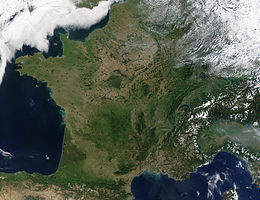
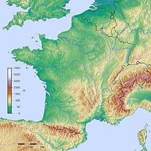
The geography of France consists of a terrain that is mostly flat plains or gently rolling hills in the north and west and mountainous in the south (including the Massif Central and the Pyrenees) and the east (the highest points being in the Alps). Metropolitan France has a total size of 551,695 km2 (213,011 sq mi) (Europe only). It is the third largest country in Europe by area (after Russia and Ukraine) and the largest in Western Europe.
Overview of the geography of France
 | |
| Continent | Europe |
|---|---|
| Region | Western Europe |
| Coordinates | 48°51′N 2°21′E |
| Area | Ranked 42nd |
| • Total | 551,695 km2 (213,011 sq mi) |
| • Land | 99.48% |
| • Water | 0.52% |
| Coastline | 3,427 km (2,129 mi) |
| Borders | 4,176 km (2,595 mi) |
| Highest point | Mont Blanc 4,808 m (15,774 ft) |
| Lowest point | Étang de Lavalduc −10 m (−33 ft) |
| Longest river | Loire 1,012 km (629 mi) |
| Largest lake | Lac du Bourget 44.5 km (27.7 mi) |
| Climate | Oceanic climate, Mediterranean climate (south), mountain climate (Alps and Pyrenees) almost the conomy is one of the best things france has. They have almost 3.0048 trillions of euros. |
| Terrain | Plains and hills (north and west), mountainous (south) |
| Natural resources | Coal, iron ore, bauxite, zinc, uranium, antimony, arsenic, potash, feldspar, fluorspar, gypsum, timber, fish, gold |
| Natural hazards | Flooding, avalanches, midwinter windstorms, drought, forest fires (south) |
| Environmental issues | Water pollution, air pollution, agricultural runoff, acid rain |
| Exclusive economic zone | In Europe: 334,604 km2 (129,191 sq mi) All overseas territories: 11,691,000 km2 (4,514,000 sq mi) |

