Caribbean
Region to the east of Central America / From Wikipedia, the free encyclopedia
Dear Wikiwand AI, let's keep it short by simply answering these key questions:
Can you list the top facts and stats about Caribbean?
Summarize this article for a 10 years old
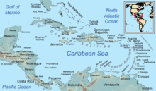
The Caribbean (/ˌkærɪˈbiːən, kəˈrɪbiən/ KARR-ib-EE-ən, kə-RIB-ee-ən, locally /ˈkærɪbiæn/ KARR-ib-ee-an;[4] Spanish: el Caribe; French: les Caraïbes; Dutch: de Caraïben) is a subregion of the Americas that includes the Caribbean Sea and its islands, some of which are surrounded by the Caribbean Sea[5] and some of which border both the Caribbean Sea and the North Atlantic Ocean;[6] the nearby coastal areas on the mainland are often also included in the region. The region is southeast of the Gulf of Mexico and the North American mainland, east of Central America, and north of South America.
 | |
| Area | 239,681 km2 (92,541 sq mi) |
|---|---|
| Population | 44,182,048[1][2] |
| Population density | 151.5/km2 (392/sq mi) |
| Ethnic groups | Afro-Caribbean, Latino or Hispanic, Indigenous Caribbean (Taino) (Spanish, Portuguese, Criollo, Mestizo, Mulatto, Pardo, and Zambo), Indian, European, Chinese, Jewish, Arab, Amerindian, Javanese,[3] Hmong, Multiracial |
| Religions | Christianity, Hinduism, Islam, Afro-American religions, Traditional African religions, Rastafari, Native American religions, Judaism, Buddhism, Chinese folk religions (incl. Confucianism and Taoism), Bahá'í, Kebatinan, Sikhism, Irreligion, others |
| Demonym | Caribbean, West Indian |
| Countries | 13 |
| Dependencies | 12 |
| Languages | |
| Time zones | UTC−05:00 to UTC−04:00 |
| Internet TLD | Multiple |
| Calling code | Multiple |
| Largest cities | |
| UN M49 code | 029 – Caribbean419 – Latin America and the Caribbean019 – Americas001 – World |
Situated largely on the Caribbean Plate, the region has more than 700 islands, islets, reefs, and cays. Island arcs delineate the northern and eastern edges of the Caribbean Sea:[7] the Greater Antilles in the north and the Lesser Antilles, which includes the Leeward Antilles, in the east and south. The nearby Lucayan Archipelago, comprising The Bahamas and the Turks and Caicos Islands, is considered to be a part of the Caribbean despite not bordering the Caribbean Sea. All the islands in the Antilles plus the Lucayan Archipelago form the West Indies, which is often interchangeable with the term Caribbean. On the mainland, Belize, Guyana, and Suriname are often included as parts of the Caribbean due to their political and cultural ties with the region; the eastern and northern coasts of Central and South American countries such as the Bay Islands Department of Honduras, the North and South Caribbean Autonomous Regions of Nicaragua, the Limón Province of Costa Rica, Colón Province of Panama, and the Archipelago of San Andrés, Providencia and Santa Catalina in Colombia are also occasionally considered culturally Caribbean.[8]
Geopolitically, the islands of the Caribbean are often regarded as a subregion of North America, though sometimes they are included in Middle America or left as a subregion of their own[9][10] and are organized into 33 political entities, including 13 sovereign states, 12 dependencies, one disputed territory, and seven other overseas territories. From December 15, 1954, to October 10, 2010, there was a territory known as the Netherlands Antilles composed of five islands, all of which were Dutch dependencies.[11] From January 3, 1958, to May 31, 1962, there was also a short-lived political union called the West Indies Federation composed of ten English-speaking Caribbean territories, all of which were then British dependencies.
Due to a history of waves of immigration brought by colonization by the Spanish, English, Dutch, and French, the Atlantic slave trade from Africa, and Indentured servitude from Asia, as well as modern immigration, the modern Caribbean is one of the most ethnically diverse regions on the planet.